info@3deepmedia.com
+44 (0)1326 330 036
Using UAVs (drones) is a highly efficient method of data collection for orthographic mapping. Using specialist flight control software we have the ability to plan automated missions to achieve specific levels of detail, by setting parameters such as altitude and overlap of images.

Accurate
Accuracy down to less than 1 cm can be achieved.
Accessible
Viewable in an interactive format across all devices.
Measurable
Using specialist software the data is measurable not just for distances but also volumes.
Efficient
Rapid data collection using the latest in UAV technology.
How aerial orthographic mapping works…
After deciding on the area or structures needing to be mapped, we use automated flight systems to plan a grid route that covers the area.
We set the drone flying at a constant speed with the camera pointing vertically downwards capturing images every couple of seconds. If extra detail is required, we can carry out additional flights at lower altitudes or from different approaches.
The data is then processed using different software systems that measure the similarities and differences between each image and stitches them together into a high-resolution, satellite-style image.
We can then accurately overlay this image using geo-referenced data, or manually position over existing maps.
Benefits of UAVs for aerial orthographic surveys
Using remote aerial systems has many benefits compared to traditional ground-based survey methods and practices.
- Speed: UAVs can cover a large area in a fraction of the time of ground-based surveys.
- Efficiency: The data can be captured in detail once and then analysed and reviewed infinitely.
- Comparable: Using automated flight systems, the exact same data can be captured again in the future and compared.
- Measurable: The orthographic maps can be accurate down to centimetres and measurements such as distance or volume can be generated.
- Safer: Aerial systems make accessing inaccessible or dangerous places much safer with reduced risk.
EXAMPLES OF PREVIOUS ORTHOGRAPHIC MAPPING PROJECTS
View some of the previous orthographic mapping projects we have worked on from around the UK and further afield.


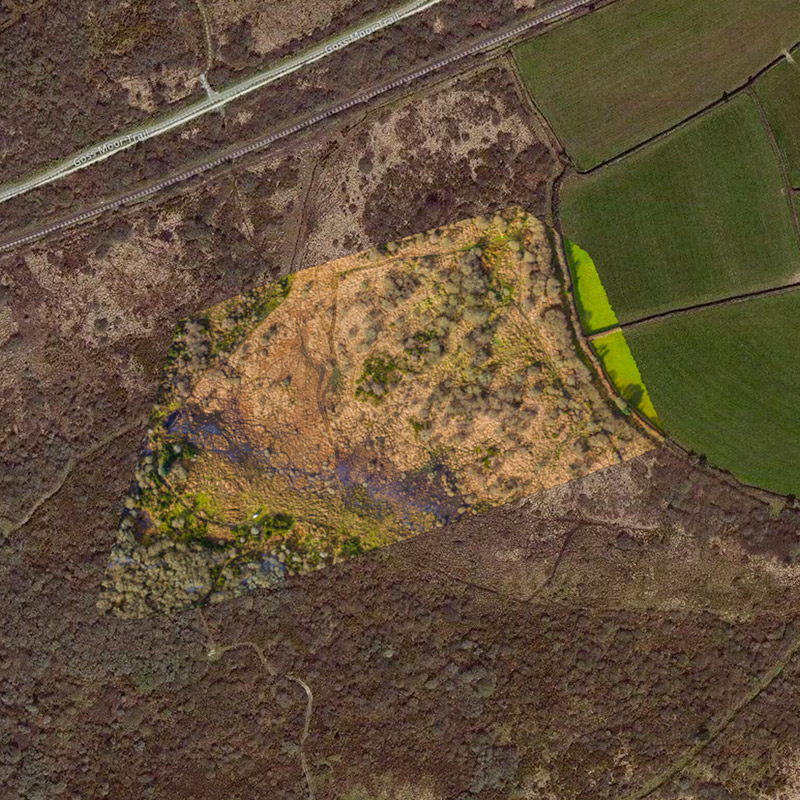

Documenting Heritage and Archaeology
Aerial systems are a cost-effective and accurate way of documenting and surveying historical and archaeological sites. Orthographic maps generated from the aerial data can be used for many different types of analysis, or further developed into 3D visualisations showing what sites looked like at different periods in time.

Geological Surveys
UAVs (drones) are arguably the fastest and most versatile method for capturing data for geological / landscape surveys. It’s also a safer alternative for locations that are difficult or dangerous to reach, such a cliff erosion inspections. An automated remote system also means that the data can be analysed again in the future from the same survey points.

Leisure & Tourism
For outdoor leisure businesses such as golf courses, showing customers what you have to offer is vital. Satalite imagery from Google is often lacking in detail especially at higher zoom levels. Orthographic aerial maps are a great way to show visitors the layout of your site and when combined with markers pinned to the terrain it serves as an interesting way to show key information about your services. With the addition of photos and videos integrated into the map, customers get a useful and memorable experience prior to and during their visit.

© All content copyright 3deep Media Ltd 2018.